Viewing entries tagged
Jordan River

Well Watered Valley

Well Watered Valley

Looking east across the Jordan Valley toward the Trans-Jordan Plateau. 

Looking east across the Jordan Valley toward the Trans-Jordan Plateau. 

In Genesis 13, we read:

Then Abram said to Lot, “Let there be no strife between you and me, and between your herdsmen and my herdsmen, for we are kinsmen. Is not the whole land before you? Separate yourself from me. If you take the left hand, then I will go to the right, or if you take the right hand, then I will go to the left.” And Lot lifted up his eyes and saw that the Jordan Valley was well watered everywhere like the garden of the Lord, like the land of Egypt, in the direction of Zoar. (This was before the Lord destroyed Sodom and Gomorrah.) So Lot chose for himself all the Jordan Valley, and Lot journeyed east. Thus they separated from each other. - Genesis 13:8-11

One of the misconceptions by people who have never traveled to Israel is that the entire land is a dry, barren wasteland. And, while there are portions of the land that are very dry (notably, the wilderness areas south of the Negeb), much of the land is green, lush, and vibrant with life. 

In the passage that I mentioned above, Abraham gives Lot the choice of the piece of land he wants to settle. Lot gazes down into the "well watered" Jordan Valley and decides to locate his family in this region. As you can see from the picture, this land is still agriculturally rich and crops are still grown in this region. 

(NOTE: Looking at the picture, you would think that the Jordan River would be visible. In reality, it is not. The river flows through the center of the Jordan Rift Valley, but sits very low and it not visible most time of the year.) 

The Jordan River

DSC_2797.JPG

Beginning at the foot of Mount Hermon, the Jordan River travels through the Hula Valley before entering the Sea of Galilee. At approximately 700 feet below sea level, the Sea of Galilee is the lowest fresh water lake in the world. After exiting the Sea of Galilee, the river twists and turns its way about 70 miles before emptying into the Dead Sea, the lowest spot on the face of the earth. 

The Jordan River is mentioned many times in the Bible. The Israelites crossed this river as they began their conquest of the land of Canaan. Elijah and Elisha crossed this river. Naaman was told to wash in this river to cure his disease. In New Testament times, Jesus was baptized at a site very near the Jordan River. 

Because the Jordan River serves as an international boundary, access to the river is not easy. This picture, taken just south of the Sea of Galilee, is one of the few places where the public can access the water's edge.

Crossing the River Jordan

IMG_1088Recently, my family and I made a trip to Florida and spent one day at Walt Disney World's Magic Kingdom park. For those of you who have been there, you have probably ridden the Haunted Mansion ride and seen the humorous gravestones that line the (sometimes rather long) queue area. On this visit, I noticed a particular tombstone and took a picture of it. It reads:

RIP: Good friend Gordon, now you've crossed the River Jordan

Ever since Joshua led the nation of Israel across the Jordan River, people have equated the idea of crossing that famous river with fulfilling a promise, or going home, or receiving your ultimate, eternal reward. We even sing songs that mention this:

"On Jordan's stormy banks I stand and cast a wishful eye, to Canaan's fair and happy land where my possessions lie."

Are you ready to cross the River Jordan?

Spring in the Jordan Valley

As I speak to people about the lands of the Bible, I am often met with surprise when I discuss the rich and fertile areas of Israel. And, while there are places like the wilderness and the Negeb that are very dry, much of the area is well watered. Recently, I watched a video by Amir Aloni of the Jordan Valley. He took the footage for the video using a drone which flew over many of the fields in the area. I encourage you to watch it as well.

[vimeo https://vimeo.com/123064814]

When I saw this video, I was reminded the passage in Genesis 13 in which Lot chose to settle in the fertile Jordan Valley when he separated from Abraham.

So Abram went up from Egypt, he and his wife and all that he had, and Lot with him, into the Negeb. Now Abram was very rich in livestock, in silver, and in gold. And he journeyed on from the Negeb as far as Bethel to the place where his tent had been at the beginning, between Bethel and Ai, to the place where he had made an altar at the first. And there Abram called upon the name of the Lord. And Lot, who went with Abram, also had flocks and herds and tents, so that the land could not support both of them dwelling together; for their possessions were so great that they could not dwell together, and there was strife between the herdsmen of Abram's livestock and the herdsmen of Lot's livestock. At that time the Canaanites and the Perizzites were dwelling in the land. Then Abram said to Lot, “Let there be no strife between you and me, and between your herdsmen and my herdsmen, for we are kinsmen. Is not the whole land before you? Separate yourself from me. If you take the left hand, then I will go to the right, or if you take the right hand, then I will go to the left.” And Lot lifted up his eyes and saw that the Jordan Valley was well watered everywhere like the garden of the Lord, like the land of Egypt, in the direction of Zoar. (This was before the Lord destroyed Sodom and Gomorrah.) So Lot chose for himself all the Jordan Valley, and Lot journeyed east. Thus they separated from each other. - Genesis 13:1-11

Podcast #3 - God Stopped The Waters At Adam

[soundcloud url="https://api.soundcloud.com/tracks/191530415" params="auto_play=false&hide_related=false&show_comments=true&show_user=true&show_reposts=false&visual=true" width="100%" height="450" iframe="true" /] The Israelites had survived Pharoah chasing them toward the Red Sea. They had spent time at Mount Sinai. They had survived forty years of wandering in the wilderness. But before they could begin their conquest of the Promised Land, they had one more barrier to cross...the Jordan River. How did this happen? Joshua 3 tells us this incredible story. And that is what we will be discussing on today's program.

Note: If you are reading this post in an email, you can visit the Podcast page on the Exploring Bible Lands website to listen to the podcast.


Podcast Links Joshua 3 - Bible Gateway

The Lowest Place On Earth

The Lowest Place On Earth

ibex.jpg

masadaToday was spent the entire day around the lowest place on the earth, the Dead Sea. After breakfast, we headed toward Masada. Our goal was to beat the crowds and the heat of the day. We arrived around 9:15 and went to the top. This is a great stop. This site is one of the top tourist attractions in Israel. From a Biblical perspective, it is interesting to see the lifestyle of King Herod and knowing that it was this man's family that was the ruling party in the First Century. Our next stop was En Gedi, which included a brief hike up to a waterfall. During David's life, he went to En Gedi and after visiting the site, you know why. In the middle of the Wilderness of Judea, it was this location that had water. Even today, water continually flows from the mountains as it makes its way to the Dead Sea.

Traveling north up the coast, we found ourselves at Qumran, the site where the Dead Sea Scrolls were found. We enjoyed learning about the Essenes and their lifestyle in this arid climate.

Our next stop was at the traditional baptismal site of Jesus. The Bible tells us that John the Baptist was baptizing at "Bethany beyond the Jordan", which means that John was baptizing at some location on the other side of the Jordan from where we were located. Due to various reasons, the River Jordan is very small through here. It is only about 20 feet wide and about 2 feet deep. In many ways, it is very depressing. However, the Israelis, Palestinians and Jordanians are all working on this problem.

(Side note: While we were visiting this site, we learned that the mother of our driver had passed away. The travel company made arrangements for a new driver to meet us within a few minutes. I feel bad for Fawzi, our driver. I have known him for about five years and know that he and his family are going through a rough time right now.)

dead_seaJericho was next on our list. This site is very special for me because so many Biblical sites took place here. We discussed many of these events as well as the architectural finds that have been made here.

Having a smaller group (about 30) has its advantages. We were able to squeeze some extra time in our schedule to take everyone to the Qumran kibbutz and allow them the opportunity to float in the Dead Sea. And, they did!

Overall, another great day today. Tomorrow will be a walk around the Old City of Jerusalem which is always very interesting. Until then...

Northern Galilee

Northern Galilee

sea_of_galilee_sunrise.jpg

This morning's sunrise was partly cloudy. Therefore, the initial sunrise over the Sea of Galilee wasn't impressive, but a few minutes later, the suns rays shined through the clouds to remind us that "The heavens declare the glory of God". hazorAfter a great breakfast, we headed north of the Sea to the Hula Valley. Our first stop was at the ancient city of Hazor. The location of this city is vitally important as it controls all traffic on the Via Maris in ancient times.

From there, we drove to the northern edge of the country of Israel and viewed the site of Abel-Beth Maacah. Although it is impossible to take an entire tour group to the site, this is a favorite of mine because of how the city is situated on a hill with a commanding view of the surrounding area. Although we didn't stay long, our visit to the city went much better than Sheba's (2 Samuel 20).

We then drove a little farther north to the Israeli city of Metula to have a view over into the country of Lebanon.

dan_solomonic_gateTel Dan was our next stop. After walking through the nature preserve, we arrived at the High Place built by King Jeroboam, first king of the northern kingdom of Israel. This single bad decision by King Jeroboam basically sealed the fate for his country. The people followed him and they never recovered. We walked through the Solomonic gate and finally viewed the ancient Canaanite gate.

Leaving Dan, we traveled to Banias (ancient Caesarea Philippi). The cultic worship that was evident during the time of Christ makes Peter's answer to Jesus' question so much more meaningful ("Jesus is the Christ, the son of the living God").

jordan_riverAfter driving through the Golan Heights (with a stop of a view toward Syria), we arrived at the Jordan River, just north of the Sea of Galilee. Due to the shortage of rain during the most recent rainy season, the flow was probably lower than I have ever seen it. But, it is always a thrill to be able to see such a famous river.

We arrived back at the hotel tired, hungry and pleased with the day. Heading to bed to get a good night's rest before tomorrow.

From Israel, Shabbat Shalom.

Water Flowing From The Sea of Galilee

The Senir River in northern Israel.  The Senir River drains the snow melt from Mount Hermon into the Jordan River north of the Sea of Galilee.I was thrilled yesterday to read a story in the Jerusalem Post concerning an increase in the amount of water that they are allowing to flow into the Jordan River. In the past, I have written a number of posts about the water levels in the Sea of Galilee, Jordan River and the Dead Sea. To recap, you can read them here:

However, over the winter, the country of Israel has received a large amount of rain. Mount Hermon, located in the northern part of the country, had a large amount of snow. That snow is now melting and is draining into the Sea of Galilee. About a month ago, Ferrell Jenkins supplied two pictures of the difference in the Sea between last September and April.

Slow water flow of the Jordan River at Qasr al-Yahud.  The Jerusalem Post article mentions that beginning next month, they will release an additional 1,000 cubic meters of water per hour into the Jordan River. I'll be anxious to see what difference this makes further downstream. Currently, by the time the Jordan River flows at Qasr al-Yahud (the traditional Jesus baptismal site in Israel), it is hardly flowing at all. You can see this by looking at the picture to the right.

HT: Todd Bolen

Jezreel

Jezreel (center) and the surrounding area.  Picture from the Jezreel Expedition Facebook Page, taken by Todd Bolen Earlier today, the Jezreel Expedition Facebook page updated their cover photo. All I have to say is "wow". That is a fantastic aerial shot of Jezreel as it overlooks the southeastern corner of the Jezreel Valley and the Valley of Harod.

This picture is facing almost due east. Jezreel is the light brown area just below the exact center of the picture. The northern end of Mount Gilboa is off to the right and the Transjordan Plateau is in the distance. The Jordan River, which sits in the Jordan Rift Valley is not visible as it falls below the land line between Jezreel and the Transjordan Plateau.

How many Biblical events can you name that happened in this picture? Well, here is a list to get you started.

  • Gideon narrowed his army from many thousand to only 300 men at the Spring of Harod. That spring is located at the foot of Mount Gilboa in the closest shady area just beyond Jezreel. Later that night, Gideon attacked the Midianites near the Hill of Moreh, located just off of the picture to the left. (Judges 7:1-25)
  • Saul was killed on Mount Gilboa. When the Philistines found Saul's body, they took it and hung it over the walls at Beth-Shean. Beth-Shean sits about halfway between Mount Gilboa and the Jordan River (not visible from this angle). (1 Samuel 31:1-10)
  • Jehu rode "furiously" through this area. Jehu had been anointed by a prophet to be the next king of Israel at Ramoth Gilead. Ramoth Gilead was located on top of the Transjordan Plateau in the distance in this picture. A Jehu was riding back to Jezreel, the men in the tower saw him coming up the valley you see in the picture. (2 Kings 9:1-29)
  • This view is probably the last view that Jezebel saw just before she was pushed out a window to her death. (2 Kings 9:30-37)

Many other Biblical events happened within the view of this picture. In addition, anyone traveling from the Galilee area (to the upper left) to the Jerusalem area could have come through this area.

To the Jezreel Expedition: Thanks for supplying this picture! And to Todd Bolen, thanks for taking the picture! It was a great reminder of all of the things that happened here.

The Ark in the Jordan River

The Jordan River, just north of the where the river flows into the Dead Sea.This is the second in a series of posts featuring some of the locations where the Ark of the Covenant resided. The first post of the series featured the Plains of Moab. Now, we'll move on to the Jordan River. Granted, the Ark really didn't reside in the Jordan River, but merely paused there as a demonstration of God's power. As the Israelites approached the Promised Land, there was one remaining geographical stumbling-block in their way, the Jordan River. The Jordan River is a 250 kilometer (about 150 miles) river that flows from north to south along a fault line in eastern Asia. Today, a majority of it serves as the boundary between Israel & the West Bank to the west and the Hashemite Kingdom of Jordan to the east.

The Jordan River as it flows underneath the old Allenby Bridge. This picture was taken around 1920.A visit to the Jordan River today in the area where the Israelites crossed could leave the visitor with some confusion about why a miracle was needed to get the people across. As you can tell from the picture at the top of this post, the Jordan River is not much to look at and would not have been a major impediment to the Israelites as they crossed into Canaan. (I have discussed the low level of the water in other posts.) However, this is not what the river looked like at that time. Of course, we don't have photographs from that time, but we can make some estimates. Even as little as 100 years ago, the width of the Jordan River was much wider than it is today. Consider the other two pictures associated with this post. The first picture shows the Jordan River as it flows under the old Allenby Bridge. This picture was taken around 1920 and as you can tell, the river is much wider. The second picture is much more striking. This picture, taken in 1935, shows how the river could easily flood the region during the rainy periods. (NOTE: Both of these pictures are from Volume 3 of The American Colony and Eric Matson Collection.)

Now, let us look back at our story. In Joshua, we read:

So it was, when the people set out from their camp to cross over the Jordan, with the priests bearing the ark of the covenant before the people, and as those who bore the ark came to the Jordan, and the feet of the priests who bore the ark dipped in the edge of the water (for the Jordan overflows all its banks during the whole time of harvest), that the waters which came down from upstream stood still, and rose in a heap very far away at Adam, the city that is beside Zaretan. So the waters that went down into the Sea of the Arabah, the Salt Sea, failed, and were cut off; and the people crossed over opposite Jericho. Then the priests who bore the ark of the covenant of the Lord stood firm on dry ground in the midst of the Jordan; and all Israel crossed over on dry ground, until all the people had crossed completely over the Jordan. - Joshua 3:14-17

The Jordan River, in 1935, as it overflowed its banks. The Allenby Bridge can be seen in the upper-right portion of the photographAs the Israelites approached the Jordan River, it had overflowed its banks. The priests carried the Ark of the Covenant and as they put their feet into the waters of the Jordan River, it dried up. The waters piled up at Adam, and the Israelites were able to cross on dry land. After all of the Israelites had crossed, the priests walked out of the riverbed and the Ark of the Covenant entered the Promised Land for the first time. We will pick up the story here in our next post.

The Ark in the Plains of Moab

View looking west from Mount Nebo at the Plains of Moab across from Jericho.When the Israelites were encamped at Mount Sinai, God gave instructions to build a gold-plated, wooden box. This box became known as the Ark of the Covenant and it remained in the possession of the Israelites for hundreds of years. They carried the Ark before them and it led them into battle. I thought that it would be interesting to take a look at some of the places where the Ark resided and discuss them in a series of posts. After wandering in the wilderness for 40 years, the Israelites approached the land of Canaan from the east and temporarily settled in the Plains of Moab. Moses ascended to the top of Mount Nebo where God showed him the land that was being given to the nation of Israel. After Moses died, the Israelites stayed in the Plains of Moab while they mourned his death.

And the children of Israel wept for Moses in the plains of Moab thirty days. So the days of weeping and mourning for Moses ended. - Deuteronomy 34:8

The plains of Moab stretched north-to-south along the eastern side of the Jordan River, opposite from the city of Jericho. The land is rather flat and ranges from 5-10 miles wide before rising dramatically into what we commonly call the Trans-Jordan plateau. A majority of it lies below sea level, but despite the arid climate, crops and agriculture flourish.

Later, we recognize this location as the same area where Elijah was taken into Heaven in a whirlwind. In New Testament times, this was part of what we know as Perea. The location of Bethany beyond the Jordan was also in this same area.

2012 Israel Trip - Day Four

2012 Israel Trip - Day Four

DSCN0429.jpg

Well, today got off to a strange start…but, as always, everything works out in the end. We were originally scheduled to take a boat ride on the Sea of Galilee. However, there was no boat at the dock at 8:30. So, our tour guide called the rental company and there was a miscommunication on the date. They had us scheduled for tomorrow morning. No matter. With only about a million things to see and do in Israel, we just shuffled our schedule a bit, loaded the bus and headed out. 
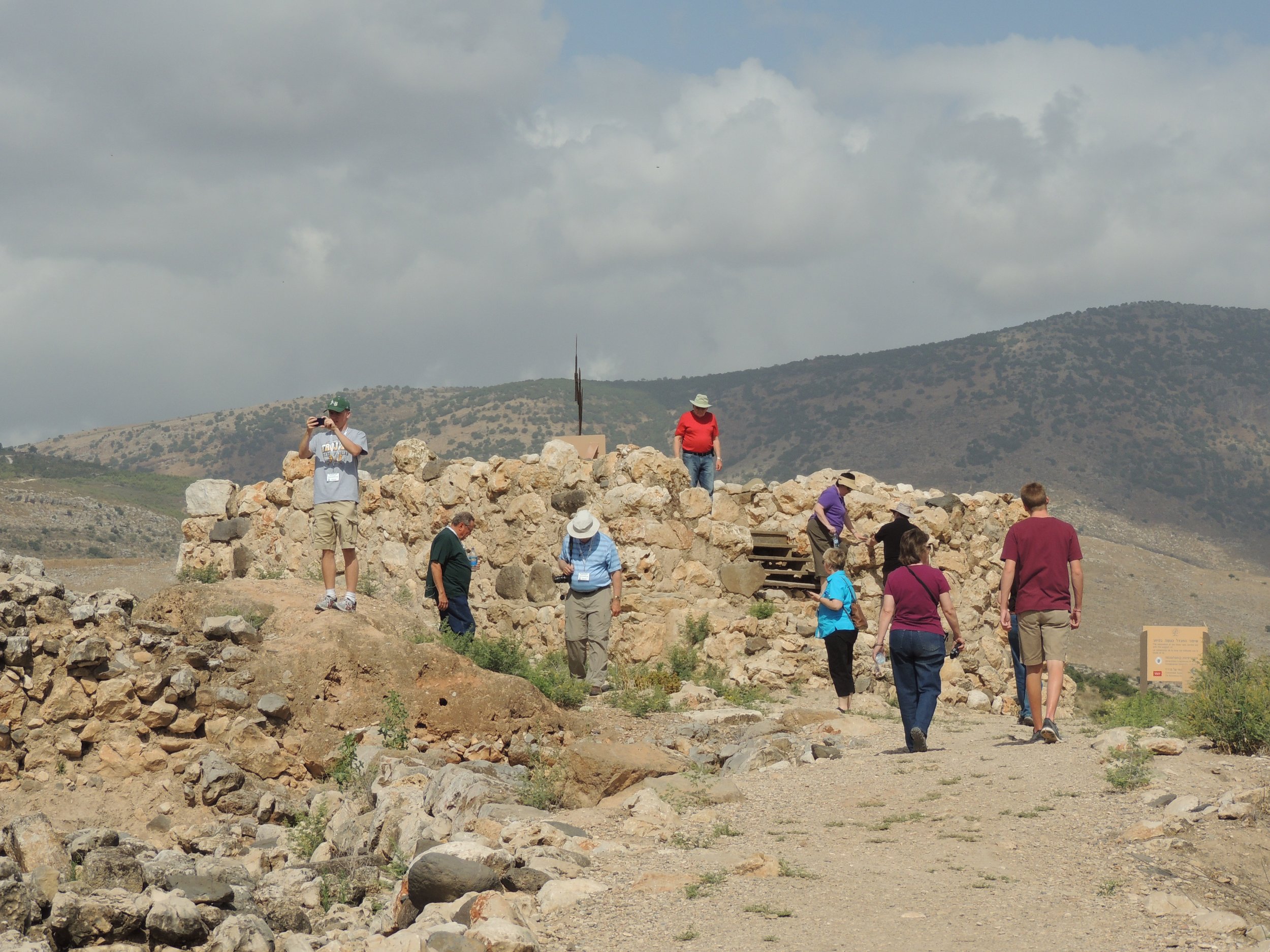
We spent the entire day north of the Galilee region. Our first start was at the city of Hazor (it is pronounced "hot-sore"). Hazor is only mentioned a few times in the Bible, but it was a very important city. When the Israelites came into the land, Joshua conquered the city as it was one of the most important cities at that time. Later, Solomon built huge walls at Hazor to protect it. Many of these walls (including parts of the gate) are visible today. By standing on the tel, you can easily see the geographical importance of the city.

From Hazor, we made a brief stop at Abel Beth-Maacah. If you consider yourself a Bible student and don't recognize the name, don't feel bad. It's only mentioned a couple of times, most notably in 2 Samuel 20. Go back and read the story again. (Warning: The story doesn't end well for Sheba.) The location of this city has been known for years, but they have just started initial excavations of the tel this year. I mentioned this in an earlier blog post.

Our next stop was an unexpected bonus. In the First Century BC, Herod the Great erected three temples to Augustus. The first one was at Caesarea Maritima. The second was at Samaria. The third was near Paneion. For years, it was thought that this temple was located at the traditional location of Caesarea Philippi. However, recent excavations at Omrit has cast doubt on that. At Omrit (which is located about three miles from Caeserea Philippi), they have found the ruins of a Roman temple that is similar to the ruins at Caesarea Maritima and Samaria. The site is located along a VERY SKINNY single lane road that a regular car could barely navigate. However, our expert bus driver, Fawzi, was determined. After a few minutes and several near misses of trees, etc, the site was within view. It was fantastic to see it and help us to better understand the time of the first century.

From Omrit, we went to Dan. The city of Dan was originally called Laish until the Danites conquered the city after the conquest. The Danites were originally given land along the Mediterranean coast, but due to their neighbors (Philistines), they decided to relocate to Laish, which they renamed Dan. Dan became a very powerful city in Solomon's time. By the time of the Divided Kingdom, Jeroboam constructed a "high place" so that the nation of Israel could come here to worship the false god Baal. Archaeologists have found the "high place" and I have included a picture of the steps leading up to it.

Our next stop was at Caesarea Philippi, where Jesus asked his disciples "…but who do you say that I am?" Peter famously answered, "Thou are the Christ, the Son of the Living God". Ferrell Jenkins spoke to us about the importance of Jesus asking his disciples this question at this location. Seeing the area helps you to understand the true meaning of the conversation.

On our way back to the Galilee area, we drove back through the Golan Heights which is now under Israeli control since the Six-Day War in 1967. For much of the ride, you were right on the border of Syria. How close were we? Well, check out the picture. At one of our stops, I was able to take a picture of a Syrian flag flying in one of their cities.

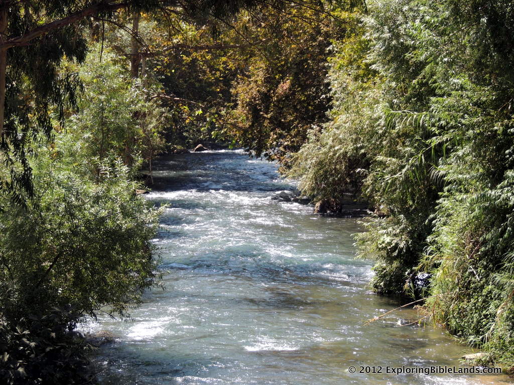
Finally, we made a brief stop by the Jordan River just north of where it flows into the Sea of Galilee.

Overall, it was a great day. Our boat ride has been rescheduled for tomorrow morning, so we'll try to enjoy that tomorrow. Until then…Shalom.

BONUS: As I understand it, the Third Grade at Athens Bible School is following my blog and mentioning the places I mention in their Bible Class. I thought that I would throw in a bonus picture for all of them. Being in another country is really interesting. You have to deal with different languages, different customs and a different way of life. However, occasionally, you come across something that reminds you at home. That happened at lunch today. We stopped by a familiar restaurant. From the picture, can you guess where we stopped?

Good News About Water

Good News About Water

IMG_2104.jpg

Throughout history, civilizations have lived and died by their proximity to water. The Mediterranean Sea. The Nile River. The Red Sea. The Sea of Galilee. The Jordan River. The Dead Sea. This is just a small list of the bodies of water that is mentioned in the Bible. When I traveled to Israel and Jordan in 2010, I was very interested in seeing many of these bodies of water. However, I was not altogether thrilled with what I saw. The water flowing through the Banias River in Caesarea Philippi was beautiful. Having recently tumbled down from the heights of Mount Hermon, it was crystal clear and sounded refreshing as it jumped and skipped over rocks and small waterfalls. The Banias is one of several streams that feed into the Jordan River north of the Sea of Galilee. The Sea of Galilee is a wonderful lake that is surrounded by hills on all sides. However, its surface elevation is very erratic and fluctuates up and down based on the amount of rain the area receives. At 211 meters below sea level, the Jordan River leaves the Sea of Galilee and meanders down to 423 meters below sea level at the Dead Sea. Along the way, the Jordan River transforms from a flowing river about 15 meters wide to a 2 meter wide sludge that creeps along by the time it gets to Qasr el-Yahud (picture at right), the traditional site of Jesus' baptism. Consequently, very little water is getting to the Dead Sea and is currently evaporating at a rate of one meter per year.

What's happening? Well, much of the water is being redirected from streams and tributaries leading to the Jordan River. It is being redirected mostly for domestic purposes (drinking water, crop irrigation, etc). While the reasons are legitimate, the shortage of water is having a profound impact to the area.

Luckily, people over there recognize the problem and are making changes to help. Through water recycling and conservation, Israel is preparing to add more water to the ecosystem. If they can continue this, and if the countries of Jordan and Syria can also get involved, this will help the situation tremendously.

If you are interested in keeping up daily with the water level on the Sea of Galilee, you might want to follow the Kinbot Twitter account.

HT: Ferrell Jenkins, Todd Bolen